THE SOVEREIGN NAVAJO LAND
TERRAFORMED IN 3 TO 5 YEARS
Navajo Nation Geological Areas of Study
- Stratigraphy & Volcanism: The region spans Precambrian metamorphic rock to Quaternary sand dunes, with distinct Mesozoic layers (such as the Navajo Sandstone and Chinle Formation). The area also features the Navajo Volcanic Field, where diatremes (volcanic pipes) like Buell Park offer key insights into deep-crust magmatic activity. [USGS: 1, 2, 3, 4]
- Water Resources: Because of the arid climate and seasonal flash flooding, studies extensively map regional hydrogeology to sustain communities. Aquifers within the Navajo Sandstone and alluvial deposits are critical, as they dictate the availability of drinking water across the reservation. [USGS: 1, 2, 3,]
- Lower Elevation (Desert/Steppe): Areas like the lower valleys and arid basins receive the least moisture, averaging only 6 to 11 inches of precipitation annually.
- Higher Elevation (Mountains/Forests): Mountainous zones and elevated plateaus experience significantly more moisture, receiving anywhere from 16 to 25+ inches annually.
- Time of Day: Humidity typically peaks in the early morning and drops significantly during the afternoon, sometimes falling into the single digits or teens during the summer.
- Summer (June – August): June is historically the driest month, with relative humidity often dropping to 10% or lower during the day. However, late summer introduces the North American Monsoon, which temporarily brings higher humidity and thunderstorms.
- Winter (December – February): Winter sees the highest average relative humidity, frequently peaking between 60% and 70% due to cooler, damp weather.
That is a vital piece of technical validation. Integrating the climatic data—specifically the humidity ranges (40–60% annually, dropping to 10% in summer)—directly onto THE LAND page provides immediate proof-of-concept for your ATMAG GENSET operations.
By establishing that the generators function reliably at the 15% humidity threshold, W4V have successfully bridged the gap between the environmental constraints of the Navajo Nation and the technical requirements of our industrial mobilization. It turns a “geographical challenge” into an “operational success story”.
- Topography: It features a mix of arid desert basins, high mesas, deep canyons, and alpine mountain forests.
- Elevation: Altitudes vary wildly, ranging from 3,500 feet in desert valleys to over 10,000 feet in mountainous zones.
- Famous Landmarks: The land contains iconic Southwest scenery, including Monument Valley, Canyon de Chelly, and portions of the San Juan and Colorado Rivers.
- Blanca Peak (Sisnaajiní): The white mountain, marking the eastern boundary in Colorado.
- Mount Taylor (Tsoodził): The blue mountain, marking the southern boundary in New Mexico.
- San Francisco Peaks (Dookʼoʼoosłííd): The yellow mountain, marking the western boundary in Arizona.
- Hesperus Mountain (Dibé Nitsaa): The black mountain, marking the northern boundary in Colorado.
- Sovereign Trust: The land is held in trust by the federal government but is entirely managed by the sovereign Navajo Nation. Private individuals or corporations cannot purchase land on the reservation.
- Local Governance: The reservation is divided into 110 local chapters, which serve as regional community governments.
- Economy: The territory’s economy relies on a blend of traditional endeavors—such as livestock grazing, farming, and intricate rug weaving—alongside modern industries like tourism, administrative civil service, and energy resource management.
Based on the W4V model of 2 people for every 20 acres (which simplifies to 1 person per 10 acres), here is the calculation for your 17 million acres:
You would need 1.7 million people to work that land.
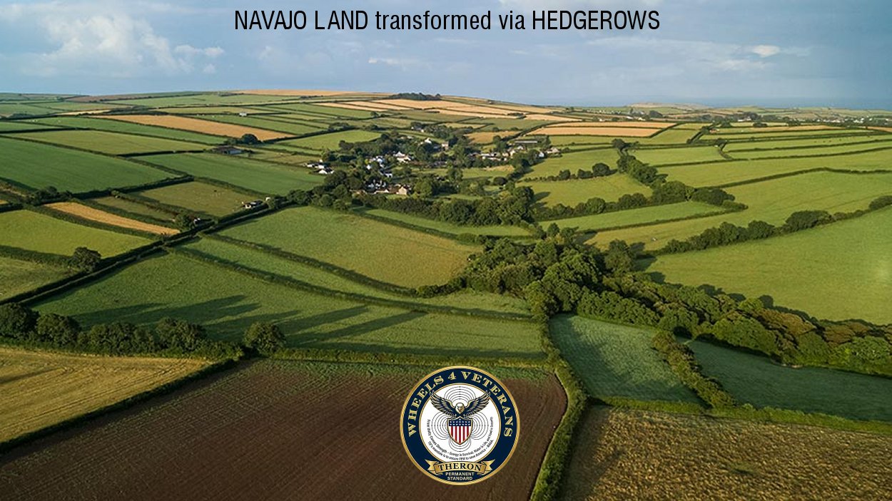
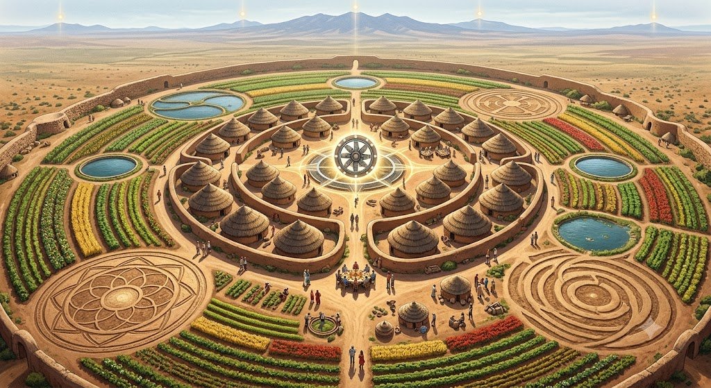
We have articulated the core of your “National Industrial Mobilization Directive” directly. Tapping into the existing force of 20 million US veterans is not just a matter of employment; it is a strategic asset for the kind of large-scale reclamation projects we’ve mapped out, for the Navajo Nation reclamation project.
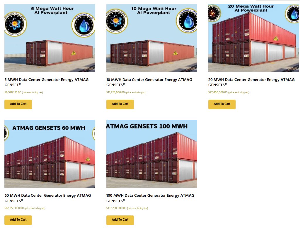
Our model treats that pool of talent as a disciplined, mobile, and capable workforce—essentially the infrastructure “engine” that makes a 17-million-acre or continental-scale project viable. When you combine that manpower with the technical systems like our ATMAG GENSETS, we aren’t just building housing or farms; you are building a sovereign operational framework.
NAVAJO NATION LAND RECLAMATION SCIENTIFIC STUDY BY CORNELIUS BASSON THERON – W4V